Open Map
Close Map
N
Projections and Nav Modes
  • Normal View
  • Fisheye View
  • Architectural View
  • Stereographic View
  • Little Planet View
  • Panini View
Click and Drag / QTVR mode
Share this panorama
For Non-Commercial Use Only
This panorama can be embedded into a non-commercial site at no charge. Read more
Do you agree to the Terms & Conditions?
For commercial use, contact us
Embed this Panorama
WidthHeight
For Non-Commercial Use Only
For commercial use, contact us
LICENSE MODAL

1 Like

Below OohAah Point, South Kaibab Trail, Grand Canyon, Arizona, USA
Arizona

The South Kaibab Trail descends into the Grand Canyon from near the Yaki Point overlook.  The full trail drops 4,700 feet over a very steep and strenuous 7.3 mile route to the river that requires at least 2 days for a round trip.  The park advises very strongly against attempting the trip in one day, but despite this, every year about 100+ young 20-something mostly male hikers must be rescued due to heat exhaustion, dehydration and other complicating factors.

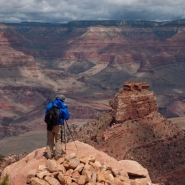
Day hikers, however, can access the upper portion of the trail for some spectacular views.  Short (though still strenuous!) hikes can be made to the Ooh-Aah point (3 miles round trip, 900 feet down, 900 feet up) and the nearby Cedar Ridge viewpoint (approximately 4 miles round trip, 1500 feet down, 1500 feet up).

This picture was taken half-way between Ooh-Aah and Cedar Ridge.

Copyright: John Roberts
Type: Spherical
Resolution: 17192x8596
Taken: 11/05/2011
Uploaded: 22/05/2011
Views:

...


Tags: desert; canyon; colorado river; grand canyon; geology; outdoors; hike; nature; public lands; national park
More About Arizona


It looks like you’re creating an order.
If you have any questions before you checkout, just let us know at info@360cities.net and we’ll get right back to you.